|
|
Geomorphology
Apuan Alps
landforms and deposits
|
|


 |
Relief landforms
The Apuan Alps
are characterized by a physical landscape with Alpine features or perhaps
features more similar to those of the Lombard Prealps, if the famous
comparison by Antonio Stoppani in “Il bel paese” (The beautiful
Country) (1876) is to be recalled. The geologist compared the fields of the
Po Plain to the Ligurian Sea because of their being flat at the foot of the
mountains. The range’s sharp and therefore “Alpine” morphology is more
evident on the coastal side. The inland side has similar characteristics but
its profile is slightly more gentle.
|
|
|
|
As a matter of fact, there is “asymmetry” on the main two sides of
the range because of different levels of steepness and the overall
direction of the mountain range owing to structural more than
morphogenetic reasons.
Since the Middle-Late Pliocene onwards, the differences between the two
sides of the Apuan Alps have greatly increased as the denudation process,
depending on tectonic rather than erosional elements, developed within
complex uplift and quiet stages of the Apuan range. The axis of the range
was oriented by the deformation geometry which was also responsible for the
position of carbonate formations along the main alignment of the range
itself.
|
|
|
Therefore, the coastal side was
characterized by an early exposure of marble and
metadolomites as well as a rapid and intense erosion of the valleys
not least because of the occurrence of Paleozoic Phyllites in the
west, now denudated and therefore more easily erodible.
On the other
hand, on the inland side the evolution of the physical landscape was
characterized by a long period during which the Tuscan Nappe covered
the ‘Metamorphic Complex’. The limbs of the folds with “apenninic” vergence have accompanied the slope toward the Serchio graben
more gently.
Apuan transverse valleys, with “Adriatic flow”, were
antecedent to the late upthrust of the horst of the tectonic rift
itself. The particular distribution of plastic and rigid structural
elements, on which played mainly the fluvial morphogenetic action,
has contributed to the “asymmetry” between the two main sides of the
Apuan Alps.
On the coastal side, the Apuan Alps create a vertical
barrier with narrow and deep valleys, whereas on the inland side
slopes descend, more regularly and more similarly to the Northern
Apennines’ morphology.
Yet, the range never lowers in a uniformed
fashion as the slope is regularly interrupted by terrains with low
inclination. Moreover, the inclination angle is different but
constant on the two main sides. Orographic anomalies are
concentrated within certain altitudes (500-650; 750-850; 900-1,050;
1,200-1,250; 1,500-1,600 m) and bear the marks of past morphological
features. |
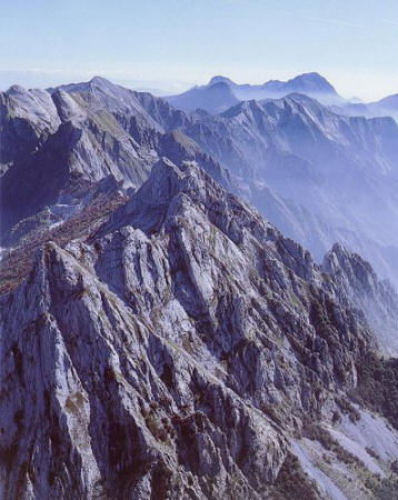
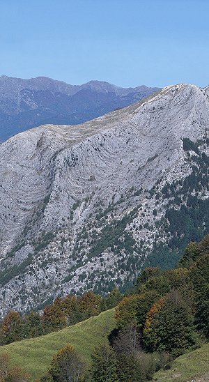
"Alpine" morphology of the Apuan mountains
|
|
|
Supposedly, they are orographic terraces
which were ancient basal levels during phases of tectonic quiet, then
re-carved by superficial running water during uplift phases.
The heritage of a relatively mature morphology is still visible in some
embedded meanders which are scattered along the narrow Apuan thalwegs. In
fact, these meanders have superposed on higher and wider valleys, cutting
the bedrock, during a phase of relif-rejuvenating.
The
layout of the hydrographic network in the Apuan Alps has been affected by
differences in the structural setting and the morphological “asymmetry” of
the main mountain sides. On the coastal side, where slopes are steeper,
valleys are radially arranged and join together at lower altitudes. On the
inland side, which is less steep, each watercourse keeps its initial
direction, perpendicular to the main ridge. Parallel valleys prevail on the
eastern side, whereas the western side is characterized by more or less
complex systems of converging valleys with dendritic or subdendritic
hydrographic networks. Apuan watercourses belong to three different
categories, depending on whether they flow into the Ligurian Sea or they are
tributaries of the Rivers Serchio or Magra. The western side is
characterized by rivers with steep upper courses reaching the sea after
crossing the short coastal plain largely originated by their deposits.
|
|
|
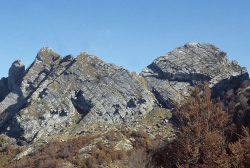
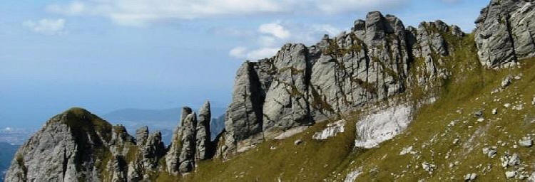
Zucchi di Cardeto:
cuèstas landscape
|
The whole coastal
surface, amounting to 315 km2,
is divided into hydrographic basins of different dimensions, of
which that of River Versilia accounts for 1/3 and is twice as large
as the surface covered by the Carriona and Frigido watercourses.
Most of the inland side of the range, amounting to 545 km2,
belongs to the hydrographic basin of the River Serchio as parallel
valleys are crossed by its right tributaries.
All tributaries have a length comprised between 9 and 14 km. The
longest is Serchio di Minucciano, followed in order by Tùrrite Secca,
Tùrrite di Gallicano, Èdron and Tùrrite Cava.
In the northern area of the inland side, totalling almost 220 km2,
watercourses, starting from streams Lucido and Bàrdine descending from the
Apuan mountains, join River Magra through the stream Aulella.
|
|
|
The presence of
highly permeable carbonate rocks across the main ridge contributes
to the existence of intermittent watercourses with semi-permanent or
temporary regimes, especially in their upper courses. A well-know
case is the karst
circulation of River Tùrrite Secca, which is characterized by a 4 km-long
underflow when flowing along the Mt. Sumbra southern side
|
|
|
Karst landforms and deposits
Despite heavy rains, the central part of the main range is arid and bare on
the surface, as rainwater is immediately absorbed by the carbonate bedrock
and released in large, complex hypogean karst Systems. Water flows down into
the mountains and, upon reaching the impermeable Paleozoic basement, it
emerges from karst springs located between 200 and 500 m of altitude. The
phenomenon is evident on the coastal side and it is often the reason for the
extension of the hydrogeological basin, larger than their hydrographic
basin. Water is captured from the eastern to the western side of the ridge
through underground paths in karst aquifers. This creates larger catchment
areas for Rivers Frigido, Versilia and Carriona compared to those created on
the surface by the watersheds.
Despite large areas of carbonate rocks outcrop, the epigean karst forms in
the Apuan Alps are not well developed in medium and large scale. In these
formations harsh and steep orographic features contributed to other
morphogenetic processes, which is why epigean phenomena are mainly
represented by small karst landforms. They are particularly common on pure
calcareous rocks (Marble and “massiccio” Limestone) characterized by intense
fracturation, high infiltration and scarce vegetation cover.
|
|
|
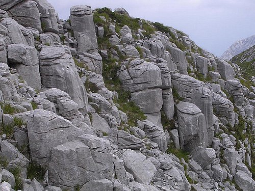
Hell's Valley (Mt. Pania): epigean
karst landforms
|
The most common microforms, the karren, are solution pits, grooves and
runnels. Karren fields are widespread at high altitudes, where the snow is
more persistent and rocks are more fractured forming a karst landscape with
clints and grikes. Dolines and shallow wells are less frequent and amount to
180 units in the whole mountain range.
They are morphoscultpures of various
dimensions, from metres to decametres long, often quite deep and therefore
with a bowl or funnel-like shape or even snow dolines.
Dolines are usually
either isolated or gathered in small groups (Campocecina, Spallone, Pian
della Fioba, Passo Sella, Vetricia, etc.) in areas with little inclination
and facing north-eastern quadrants.
The north-eastern side of Mt.Tambura in
Carcaia and, to a lesser extent, the northern side of Mt. Pisanino are
characterized by an unusual karst landscape with numerous concave
dissolution forms. |
|
|
Epigean forms have seen a reduced development, whereas hypogean karst
phenomena in the Apuan Alps acquire paramount importance and extreme value.
The Apuan Alps boast 19 out of the 50 deepest caves and 8 out of the 50
longest karst cavities in Italy. The Geopark is also home to
Italian all-time records: Abisso Paolo Roversi (Paolo Roversi Abyss), the
cave with the largest difference in heights (1358 m) and Antro del Corchia,
the longest karst Complex (~ 60 km).
|
|
|
So far speleological research has found more than a thousand karst caves
formed by gravitative hypogean circulation, both in vadose and phreatic
conditions, from high-altitude infiltration areas to low-altitude emergence
areas. The Apuan caves are mainly characterized by wells, sometimes in a
sequence, which have developed in the vertical transfer zone of infiltration
water. They were originated from small superficial absorption fractures
which then expanded and deepened by corrosion until they reached huge
differences in heights, sometimes exceeding a kilometre. Caves originated by
horizontal water transfer are less frequent but not unusual. They are
characterized by sub-horizontal tunnels and labyrinths on gentle slopes
originated near the saturated zone during phases of tectonic quiet of the
Apuan Alps. There are tipically phreatic morphologies (pressure conduits) or
morphologies conducting rainwater (canyons).
Karst Complexes with a spatial mix of wells and tunnels as a result of
polyphasic evolution are rarer. They derive from the superposition of
different generations of caves with horizontal features associated to phases
of tectonic inactivity and vertical features which formed after the
relief-rejuvenations. The largest cavities of the Apuan Alps belong to this
special category and Antro del Corchia is its main example. As a matter of
fact, the Apuan Alps still preserve traces of “ancient” karst phenomena,
probably dating back to the first phases of denudation/erosion of carbonate
rocks of the “Metamorphic Complex”. Witness the numerous “relict” tunnels
along the higher ridges of the mountain chain, which are characterized by
cavities with large section and reduced linear development. Therefore, they
are truncated segments of once larger karst Systems formed by the
progressive erosion of mountain sides and the general deepening of the
valleys. |
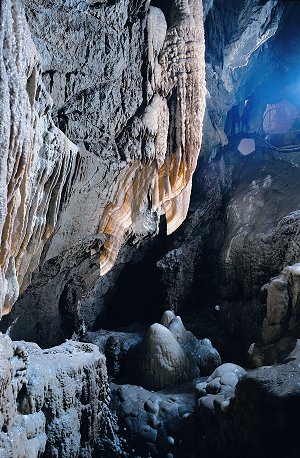
Wind Cave (Mt. Pania): pendant room
|
|
|
Glacial landforms and deposits
In the Apuan Alps, the Quaternary Glaciation left clear and remarkable
traces of diffuse erosion and deposit landforms despite the moderate height
of mountain peaks and their vicinity to the sea. The mountain range provides
an obstacle to Atlantic humid currents and nowadays causes heavy orographic
rain. It is likely that during cold phases in the Pleistocene it was
responsible for heavy solid precipitation leading to the formation of
perpetual snowfields. The glacial phenomenon mainly developed on the inland
side of the mountain range, yet recognizable and remarkable traces are also
found on the coastal side. Since glaciers were exposed to the north-east and
located on a more gentle slope, they could build up more and survive longer,
compared to the opposite side which was hampered by the relief-energy and
its exposure to southern quadrants.
|
|
|
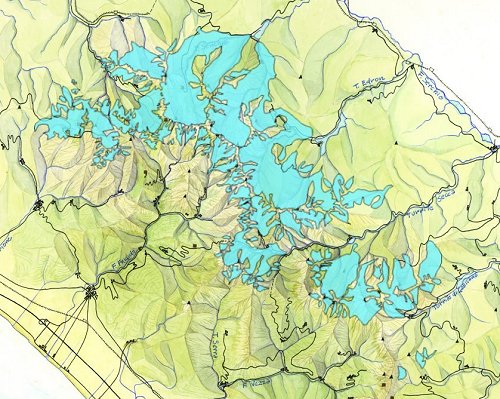
The Apuan Glaciers during the Wurm Maximum (reconstruction)
|
Attempts
to piece together the glacial extension of the Apuan Alps led to the
identification of twelve large valley glaciers on the inland side of
the range. The main glacier (Orto di Donna-Val Serenaia-La Mandria)
is likely to have extended over more than 12 km2 with a
length of 6 km. The side exposed to the sea saw the formation of few
perpetual snowfields in the shape of cirque, slope, niche, mountain,
valley glaciers. The terminal part of the tongue of the Pizzo
d’Uccello glacier reached Solco d’Equi Terme at a lower altitude of
475 m a.s.l. Whereas, the ice tongue of Arnetola basin, along Edron
valley, is thought to have descended to 550 m a.s.l. The formation
of terminal moraines at a low altitude shows the exceptional nature
of the glaciation in the Apuan Alps. As a matter of fact, it is
different from what happened in the whole Apennines and the western
Alps at similar altitudes.
Apuan
glaciers descended to very low altitudes and this was accompanied by
the exceptional low level of the snow line.
|
|
|
More recent calculation methods
estimate that the ideal line of balance between the accumulation and fusion
of snow was to be found at around 1250-1300 m a.s.l., at least on the
northern side of the range.
The formation of glaciers in the Apuan Alps is unanimously linked to the
Würm on the basis of deductive reasoning, even though a Pre-Würm (Riss?)
glaciation has been also suggested by the occurrence of cemented glacial
deposits covered by more recent melted moraine deposits (Passo del Vestito,
Val Terreno, Solco d’Equi). The glacial growth kinematics is unknown,
whereas the retreat was quick and not uniform, considering the small number
of documented late glacial phases.
The Apuan glaciation has preserved the main erosion forms. The glacial
cirque is the most widespread morphosculpture in the whole range but it is
rarely found in its typical form with semicircular vertical cliffs, a flat
bottom and a reverse slope threshold (Grotta Giuncona, Cervaiole and Catino
del Sagro are among the best preserved). A number of crests (Mt. Sumbra,
Corchia and the south-east side of Mt. Altissimo) are characterized by close
or coalescent small cirques perfectly carved on southward-looking carbonate
walls. Saddles, which lower Apuan crests, especially along the main
watershed, enabled glaciers to cross mountain sides.
|
|
|
Transfluence saddles are more common (Foce Giovo, Focolaccia, Passo
Sella, Foce di Mosceta), whereas diffluence saddles are rarer (Foce
Pianza, Passo del Vestito).
The inland side (Pianizza,
Fatonero, Orto di Donna) houses typical U-shaped glacial valleys
with a parabolic cross-section and overdeepened glacial basins which
have often been characterized by peat bogs and wetlands (Mosceta,
Fociomboli, Campocatino, Pianellaccio, etc.). Valley steps, perhaps
linked to a stop of the glacier retreat are more often found in the
furthest northern area of the Apuan Alps (Orto di Donna, Acqua
Bianca, Pisanino), whereas “Marmitte dei Giganti” (Giant’s
pot-holes) along the ditches Fatonero and Angullaja (southern side
of Mt. Fiocca and Mt. Sumbra) are likely to have a fluvioglacial
origin. Finally, roches moutonnées are not widespread. The only few
examples can be found in Val Serenaia and Arnetola.
Depositional landforms predominantly comprise glacial ridges mainly
showing terminal moraines and to a lesser extent lateral and stadial
moraines. Terminal arches are well recognizable in various inland
Apuan valleys (i.e. Canale del Libardo in Gramolazzo), whereas
Campocatino depression boasts the best preserved morainic
amphitheatre characterized by concentric circles of ridges. Huge
glacial erratics are found in the valleys of Rivers Edron and
Serchio di Gramolazzo. In particular, marble erratics have been
subject to quarrying activity in Vagli di Sopra and Campocatino.
As it is well known, nowadays there are no active glaciers in the
Apuan Alps. Perpetual snowfields have been preserved at the bottom
of high-altitude karst wells (“snow holes”), especially in the group
of Pania della Croce, even at a few metres depth. On the surface
there are places maintaining their snow cover until the hot season
and even late summer. A case in point is the place at the bottom of
the northern wall of Mt Pizzo d’Uccello which is indicated with the
name “Corners of old snow” on the maps of the Italian Military
Geographical Institute (IGMI).
Vinca: glacial
morphology
|
 |
|
|
from right to left: Cresta Botto; Punta Carina, Punta Graziosa,
Sicilia, Ferro; Coda del Cavallo
|
|
|