Apuan Alps Geopark
how find us
Archaeomining
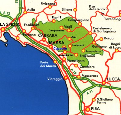
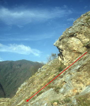
area of historical Quarries of Bardiglio Cappella is located in Fabiano di Seravezza (Lucca).
The archaeomining area is laid out below the
medieval church of San Martino alla Cappella, at the edge of the Apuan
Alps Regional Park, in the Versilia hinterland, at about 400 mt above
sea level.
It is easily reachable by car following the Marina's provincial road, through the village of Seravezza,
then the Montagna's municipal road to Fabiano-Pieve della Cappella.
Fabiano is 17 km
far from Massa, 22 far from Viareggio, 49 far from Castelnuovo Garf.,
41 far from Lucca, 50 far from Pisa:
-
Tollgate Versilia A12 (E80) Genova-Rosignano: 13 km far
-
Rail Station FF.SS. Forte dei Marmi-Querceta: 8 km far
-
Airport Galileo Galilei, Pisa: 54 km far
-
Bus service: Vaibus
opening
times
Open all year. The visit is free.
tourist information
Visitors Center
of the Park
via Corrado Del Greco, 11
55047 Seravezza (Lucca)
tel. +039 0584 756144
fax +039 0584 756144
for more information:
Apuan itineraries
Historical Quarries of Bardiglio
Cappella
It’s still uncertain when the early stages of the quarrying
industry in the quarries of the Mount of Cappella were begun. They could
have been started in the Roman Age or after the year 1000, which is actually
more probable.
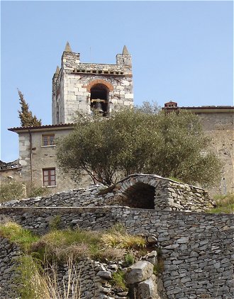
On the contrary, it’s for sure that, in the XII-XIII c., the local white
marbles as well as the ones called ‘bardigli’ (whose deep grey pale-blue
colour is unique) were used to build, in opus quadratum, the wall
face of the parish church of S. Martino an its bell tower. Moreover, some
indirect and fragmentary news testify that excavation in the Mount of the
Cappella were made in the XV c., when the stone production was largely
affected by a bad road-link with the valley bottom and the coast-valley.
On May, 18th
, 1515, the Men of the Communities of Seravezza and Cappella donated, “pro
marmoribus cavandis”, some of their appurtenances to the Florentine
Republic and People. In the acts the local marble quarries “Montes
Capellae, Finunculariae et Costae” are mentioned.
|
In 1518, Michelangelo Buonarroti built the carriage way at the bottom of
the valley. The way, which goes from Seravezza to the base of the basins of
Trambiserra and Cappella, fostered the following growth of the local
quarrying industry. |
|
In 1768, there were 21 quarries; in 1850, their number raised up to 27, with
about 114 stonecutters employed.
Up to the first half of the XIX c., the quarries of the Cappella were
concentrated in the lower part of the homonymous Mount, along the outcrop,
now exhausted, of the white marbles.
During the last decades of the XX c., the excavation activity was led also
in the highest part of the side of the mountain, which is almost close to
the parish church of S. Martino and the village of Fabiano.
For a big part of the XX c., the so-called “Vie di lizza” and the cableway
kept on being used to take the extracted blocks down to valley, on the left
side of the river Serra, where the so-called “poggi caricatori” (places
where the blocks were loaded on the “lizze”) were.
In the sixties of the same century, the path that gives access to the
quarries and the transport by tyre had been just introduced when, soon
after, the excavation industry in the marble quarries of the Cappella was
ceased. However, traces of such an activity are still enjoyable as well as a
unique suggestive mining landscape.
Visit to archaeomining area |
|
The
beauty of the quarries of the Cappella is nowadays exalted by the view
you can enjoy overlooking from the orographic terrace which extends from
the coast valley of Versilia to the main ridge of the mountain chain of
the Apuan Alps: from Forte dei Marmi to the Mount Altissimo. |
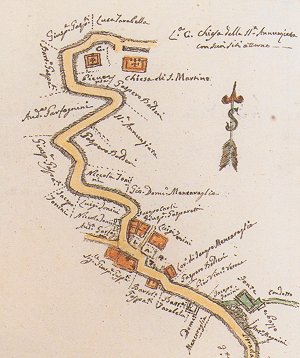 |
The Cappella-Fabiano-Riomagno road in the map
of 1784
A.S.C.S., Campione di strade
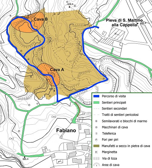 The map of archaeomining area of the Cappella |
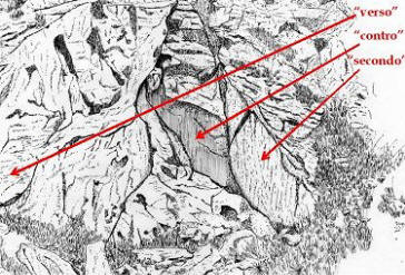
The
so-obtained and on-the-quarry-yard-already-squared products were then
taken downhill by means of big sleighs (lizze) made of beech-wood. The
“lizze” were slowly led along steep and paved paths or freighted by
mighty cableways. The map marks the spots where to find traces of such
ancient means of transport. Frequent are the holes where the “piri” were put into. The “piri” were a sort of “pioli” (pegs) where the cables, used to control the descent of the blocks along the “vie di lizza”, were wound round. "Il Monte delle Cave della Cappella è assai alto, e da esso si scuopre gran tratto di mare: dietro a lui resta [il] Monte Altissimo, ignudo, e bianco come se fosse coperto di Neve (…). Dirimpetto al Monte delle Cave, si vede il precipitoso sporto di Monte detto Trambiserra, che ha filoni di Marmo simili in tutto e per tutto a quelli del Monte della Cappella, anziché da esso si cava medesimamente il Bardiglio, ed il Marmo bianco, laonde fa chiaramente conoscere, che anticamente era unito, e continuato con quello della Cappella, ma poi è stato diviso e tagliato dall’acque del Rimagno”. (1) |
|
"Gli Scarpellini spaccano i massi a forza
di cunei, o biette (…). Lavorano a cava aperta, non a grotte (…), e dove
a più uno piace; laonde sciattano moltissimo
Marmo.
I pezzi cavati e sbozzati, stante la ripidezza del Monte, gli fanno
sdrucciolare al basso, sopra di lunghissimi scarichi di scappiole, e
rottami di Marmo: in basso gli caricano sopr’a Carri, e gli portano a
Rimagno
a lavorare e pulire; poiché li sono molte Botteghe e Magazzini di Marmi,
e vi si fanno moltissimi lavori. Per segarli e spianarli, siccome nel
paese non hanno rena buona, si servono di certa rena bianca, che cavano
dal
Lago di Maciuccoli,
e da
S. Terenzio
vicino alla
Spezia
(…)”.(2) |
|
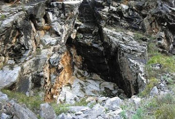
On its
right side, the route offers the opportunity to enjoy the first
museum-quarry (Quarry A in the map of archaeomining area of the
Mount of Cappella).
on the right
under |
 |
 |
 |
|
“Poco
più oltre siamo a vista delle cave della Cappella, il ravaneto delle
quali ti abbaglia l’occhio, poiché altro ivi non miri che il
biancheggiar del marmo tra l’azzurro del cielo e il verde dei vicini
castagneti. Qui è tutto movimento di picconi, mazze, pali, seghe, mine
che esplodono, grida dei cavatori e dei bifolchi che caricano i massi
enormi che rotolano traendo seco dall’alto del monte nell’alveo del
fiume dei minori e che talvolta dagli urti l’uno l’altro si spezzano:
altri ne vedi sospesi sopra il tuo capo quasi fosser per lasciarsi
all’istante; e chi per la prima volta ammira queste escavazioni rimane
invero meravigliato ed atterrito. Varie sono le proprietà di questo
monte, ma ognuno vi cava a suo bell’agio gli ordinari ed i bardigli,
essendo questi ultimi dei più belli che si conoscano e del vero colore
piccione, come li appellano gli inglesi
colour’s dove (sic).
I più pratici uomini sono occupati nelle formelle così dette, per
istaccare i massi dal monte, servendosi di mazze e zeppole; altri nel
far le mine, ed usano certo paletto detto ago da mine. Taluni vi
quadrano massi secondo le forme volute dal committente e li pongono in
istato da sottoporli alla sega. I ragazzi sono per lo più destinati a
far le quadrette da pavimento, e le donne a trasportarle in capo dalle
cave fino al caricatoio”.
Vincenzo Santini,
Vicende storiche di Seravezza e
Stazzema,
ms. del 1874, pubbl. Pietrasanta, 1964, p. 278-279 |
|
On its left side, the
route offers
the
opportunity to enjoy the second museum-quarry (Quarry B in the map of archeomining
area of the Mount of Cappella). In the second small quarry, the
progression of the excavations was made possible by means of explosives.
That’s the reason why, in the spot, there aren’t any signs of connection
with the natural clivage plains. Blocks squared by means of “mazzetta” and subbia” (piton
hammer and chisel) as well as many scales derived by the percussion
activity are visible on the yard of this second quarry too. Particularly interesting it is the presence of a handmade product endowed with steps and a column plinth testifying the advanced level of the semimanifacture of the excavated blocks. |
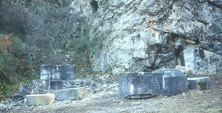 The yard of the Quarry B |
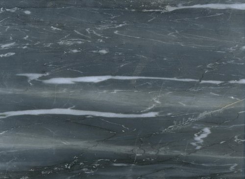 |
In both the quarries, the ‘bardiglio Cappella’ crops out. It is a marble
of a deep grey pale-blue colour striped at the bottom with light blue
lines that slightly shade off in white. |
|
‘Bardiglio Cappella’ typus |
sei il visitatore n.
dal 1° luglio 2009